Pandora's Archives No. 7 | The Disappearing Lake Harlan and Chasing a Perpetual Dream (Let Love Power Season 2)
People arriving in the Netherlands on an international flight usually land at Amsterdam's Schiphol International Airport . Passengers on the plane may notice that the altitude displayed on the onboard screen is sometimes as much as several meters below sea level before waiting for the plane to taxi to a fixed point, confirming its reputation as a "low country". But not many outsiders know that the place where the airport is located was until not long ago a vast marsh lake, which is said to have had a notorious "ship trap" (schip+hol) since the fifteenth century. This area was not used as an air base until 1916, but after World War I no longer had military use, and the take-off and landing of civil aircraft began in 1920 and gradually developed into today's scale.
Of course, this process is not easy. After all, it is not easy to transform a barren swamp into a solid and solid airport covering an area of 28 square kilometers, and the land that has actually been filled is much larger than today's Schiphol Airport, which was originally a A vast lake called Harlemmermeer, according to the 1911 edition of the Encyclopedia Britannica, was 46,000 acres before it was filled, or about 186.16 square kilometers. Considering that the area of Sun Moon Lake in Taiwan is 7.93 square kilometers, and the area of Zengwen Reservoir is 17 square kilometers, it is not difficult to imagine the original appearance of Harun Lake.
This great lake has a story of past and present life, and today it is still the archivistYan Plushi who leads the way. His professional career started from the disappearing Lake Harun, which also gives us a glimpse of the archives research. role in land planning.
This time the content is mainly <br class="smart">1. What is the significance of the disappearance of a lake?
2. Draining Lake Haren: delta engineering in the nineteenth century 3. The Netherlands that can't stop pumping: what the history of Lake Haren means for the future Appendix: Why hasn't the Netherlands been flooded yet?
Q: Why did you study the history of the disappearance of Lake Harlan in the first place?
Yan Plover: It's not that I want to study, but that there is a scholarship for such a research program, and I accept it in order to get a degree. It was originally an integrative research project, divided into three parts, with a historian conducting archival research to elucidate the origins of the nineteenth century draining of Lake Harlan, and an environmental scientist making permanent recommendations for such silting activities. Continuous analysis, and a computer scientist to develop the model. But in the end, I was the only one who completed the research, and the other two gave up halfway through.
I got my Ph.D. in 1991, which means that this research started in the late 1980s. At that time, the reason why Leiden University launched such an integrated study and provided three people with four-year scholarships has something to do with a popular view in the historical circle, that is, "the lake Harlan was drained and filled in the nineteenth century. The project went badly from start to finish", so at a time when the idea of environmental sustainability began to gain popularity, Leiden University hoped to contribute to future sustainable land use planning by studying the disappearance of Lake Harlan .
However, for a long time, people have always believed that the government only wants to eliminate floods and avoid being scolded by the public based on their distrust of the government. The archives of the special committee established for the Lake Ron drainage project show that the government and the special committee at that time actually tried to take into account the interests of all parties, such as freshwater fisheries, agriculture, military security, etc., rather than just looking at the drainage How much water risk can Lake Harlan reduce in the future?
Q: Why was Lake Harlan drained in the first place?
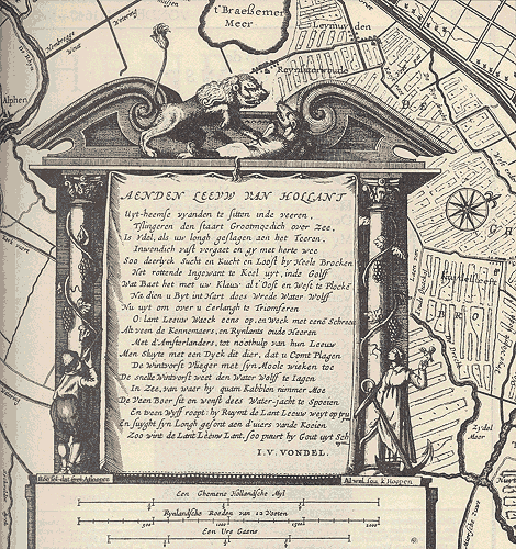
Plover : The nineteenth-century Haarlensee, a wide body of water between the three cities of Amsterdam , Haaren and Leiden , is a large lake that spans the provinces of North and South Holland. We know from historical records that Lake Harun was not a lake in Roman times, but a peat swamp. Later, it slowly evolved into a lake, and the scattered lakes gradually converged into a large lake over time. Peat swamps become lakes and continue to grow. This kind of landform change has a special name in the Netherlands, called " water wolf ". Some maps left in the seventeenth century also have a symbol of the Dutch lion and water wolf fighting. (below) , on the one hand, it can be seen that the Dutch suffer from flooding, and on the other hand, this word vividly depicts the dynamic of the lake "growing" like an animal.
Like typhoons in Taiwan, floods are commonplace in the Netherlands, but there are always some particularly serious floods that will make the then government determined to deal with water wolves. The disaster that led to the disappearance of Lake Harlan occurred in 1836. First, a hurricane came in November, which swept the water to Amsterdam in the north, and on Christmas Day a month later, another hurricane rushed the water to the south to Leiden, submerging it. Streets of Leiden. It is conceivable that the two Holland provinces could no longer bear it, so the next year King William I appointed a special committee and obtained the permission of the parliament to really kill Lake Haren.
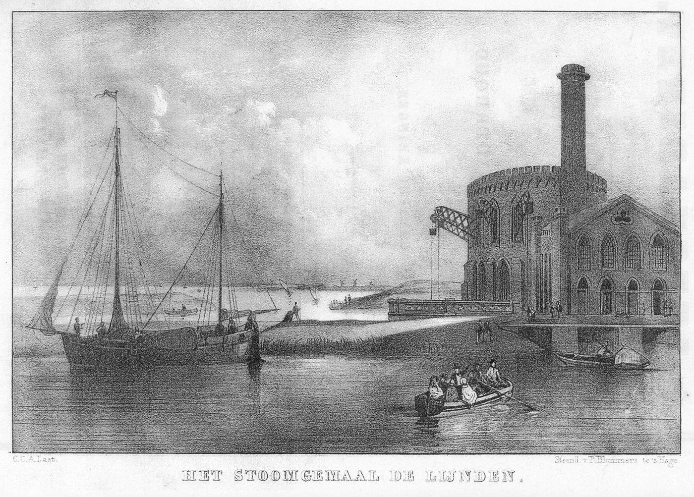
How to kill a lake? To put it simply, a circular canal must be dug along the lake to isolate the large lake so that the river water cannot flow in, and then mechanically drain all the water inside. At that time, the area of water separated by the annular canal was about 186 square kilometers. The average water depth of Lake Harlan was about 4 meters, and it was roughly estimated that about 750 million metric tons of lake water would be drained. Fortunately, there were steam engines available in the nineteenth century, otherwise, if the traditional windmills were used for this work, I would not be able to afford the time and money. From 1848, a total of three steam engines were started successively until July 1852, finally draining the entire Lake Harlan. It is quite amazing that a lake that has existed for many centuries in history has completely disappeared in just a few years.
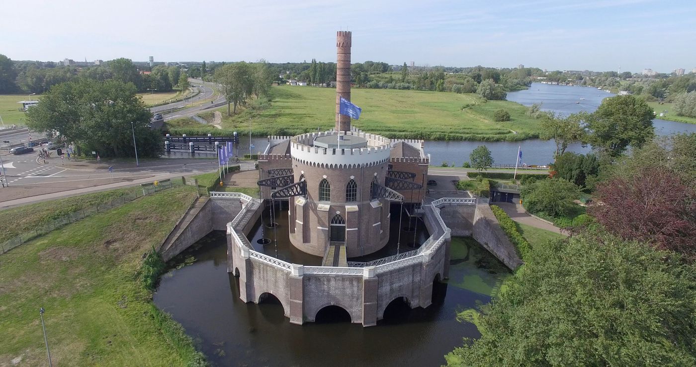
When I say steam engine, you might think in the direction of a train engine, but it takes a bigger engine to drain a lake than that. All three engines were imported from England, and one of them continued to operate after Lake Harlan was drained until it was decommissioned in the 1930s and converted into a museum.
⇩ The picture shows one of the three steam engines that drained Lake Harlan. It was also the largest steam engine at the time and is now a memorial museum.
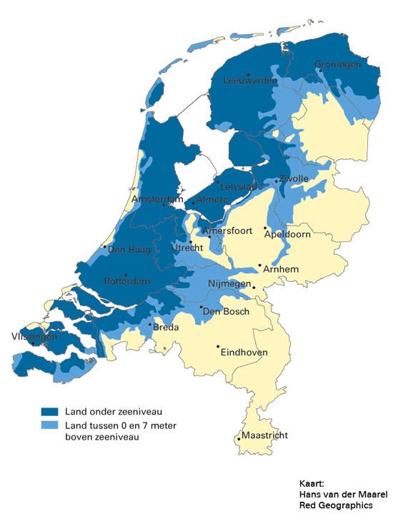
The disappearance of Lake Harlan may be the inevitable future of lakes in the Netherlands. But the cost of draining a lake can be said to be almost infinite, because once the lake is drained, the pumping activity can never be stopped. As long as it stops, the drained land will soon be flooded with water , and everything will turn white. Busy. That is to say, since Harlan Lake began to pump water in 1848, this work has not stopped, and this year is the 173rd year. In fact, about half of the Netherlands is in such a "relatively critical" state. Once the pumping stops, big cities like Amsterdam, The Hague, Rotterdam and others will be submerged under water.
⇩ The map below divides the Netherlands into three sub-divisions according to the relative height to sea level, below sea level (dark blue), 0-7 meters above sea level (light blue), and 7 meters above sea level (beige). These areas below sea level are caused by water pumping, so as long as people want to keep the land, they have to continue pumping water indefinitely.
Q: Do you regret draining Lake Harlan now?
Yan Plover: As far as I know, no, although the pumping work cannot be stopped, on the whole, everyone is quite satisfied with the result. Now the Netherlands is famous for the Deltawerken in the southwest, which is the largest flood control project in the world, and the Lake Harlan drainage project is described by current engineers as a delta project in the nineteenth century , from planning to execution. As hard as the government could do in that era, the government really did a good job - this is by no means escorting the government. When I wrote these opinions into the thesis, I was not a consultant to the government, and I was still working hard for my own degree. Besides, the government of the nineteenth century was not my escort.
During my research, I accidentally discovered that some of the concepts we hold today are not necessarily as "advanced" or "novel" as we thought. In the archives I read at the time, there was no shortage of propositions for "returning the land to water." We thought this was a new insight of our time, but such opinions have been around since the mid-nineteenth century, and there really is nothing new under the sun. Thinking from another angle, lakes have the function of regulating the flow of rivers, and floods are the biggest natural disaster in the Netherlands. The decreasing number of lakes means that the severity of floods will only increase day by day. No one could follow this a century or two earlier. Simple logic to advocate returning land to water is too arrogant.
As far as I know, the Hedwigepolder in Ziran province is now "returning to its original state". The land was only drained in the 19th century and became a silt field, but people have been competing with water for a long time here, at least dating back to the Dutch War of Independence in the 17th century. In 2005, the Netherlands and Belgium signed a treaty in which each country gave up a silt field to expand a nature reserve called Verdronken Land van Saeftinghe. Although the area of Hedwig’s silt field is only 3 square kilometers, it is still a very difficult task to “return to water” such a land that has been inhabited and used for a long time. After many setbacks, the plan was finally launched in 2018. In 2022 the water flow will be available.
⇩ Even if there is no turning back for Hedwig's silt field, people who used to live and work here still find it difficult to accept. The picture shows the slogan "Don't reply to silt fields" set up by the protesters.

Q: Since the original project to drain Lake Harlan was a national project, why was your main archival research site in North Holland? Isn't it supposed to go to the National Archives in The Hague?
Yan Plover: At that time, the national archives system in the Netherlands was still the old system. There was a national general archives, and the general archives had branches in various provinces. Since the implementation of the Lake Harlan drainage project is mainly carried out in the province of Noord-Holland, the archives are kept in the Noord-Holland branch of the State General Archives. When I was doing archival research in Haren, I did not go to the current Noord-Holland Provincial Archives, but to the North-Holland Provincial Branch of the State General Archives. Later, the National General Archives was restructured, and the provincial branches were abolished, and the archives originally in the provinces were transferred to the archives in the provinces. In other words, the archives that I read back then are indeed now kept in the North Holland Provincial Archives. In fact, this is terrible in terms of file management and messes up the whole system. I once thought about making a proposal to the National Archives, but in this case, the National Archives must find another professor of archives to review the proposal, then...it seems that there is no such person, I can't be a player and referee, so I have to forget it. .
However, as I seem to have said before, the closer the use and place of the archives are, the better. After all, more than half of Lake Harlan is in the province of North Holland, so it makes sense for the archives to remain in the province of North Holland. Furthermore, no matter what, once it enters the National Archives, the distance from the average person is always a little farther.
Q: When it comes to the connection with the locality, is there a "field" in such historical geography research?
Yan Plover: After Harlan Lake was drained, the new land continued to use this name, also called Harlan Lake, but I never visited Harlan Lake once during the research. Someone asked me why I didn't go to the place where I researched, and I replied, because that place has disappeared, and it's not only recently, it's been more than a century, and it's already changed beyond recognition, even if I go there often, yes The research itself won't help either. Instead, I went to visit the vast silt fields after I got my degree, and I felt as if a visit was the end of my research and a certain life stage.
That was my thinking at the time. Thirty years have passed since then—it will be thirty years in September this year—I think that reconnecting the past and present of a lake and presenting it to the public may be a way for the new generation to understand , a great way to imagine the future.
⇩ The southwestern part of the Netherlands is a large delta formed by the confluence of the Rhine-Meuse-Scheldt rivers and the sea. The delta project is a plan to protect the entire area. For the project, see Ted Ed's short film "Why the Netherlands Still Not submerged in water? "The picture below shows part of the Delta project.
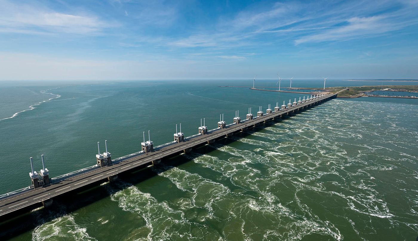
Earlier I mentioned the Hedwig silt field, which is a relatively small case with relatively easy administrative and legal issues, but even if a larger area of silt field is legally and technically feasible, it is impossible for us to Half of the Netherlands is "returned to water", and the best scenario our generation can imagine is the "delta project", which is probably the limit of our current technology. Of course, technology will continue to develop, and the delta project will inevitably have future upgrade plans, but no technology is as important as the overall people's awareness. It is not easy for us to imagine the so-called "sustainable" planning and development.
A large part of my research back then was to figure out why the Harlan Lake silt fields ended up the way we see them. I read all kinds of archives and finally realized that it was not just a project to drain the lake, but also a basic planning project. There can be rural areas, where should be used for military purposes, how should everything be distributed and arranged... This is a very complicated land plan. This planning process is something that we as future generations can refer to, because we will continue to create silt fields, and we will continue to return the land to water, and the Dutch will continue to do this until the day humans can no longer resist nature in any way. the power of.
Even if that day comes, until then, we should still do our duty as residents and plan land use well—whether it's turning rivers and lakes into silt fields, or returning silt fields to rivers and lakes. This is probably the greatest ideal that people of our age can have.
Addendum Video: Why hasn't the Netherlands been flooded yet?
TED Ed: Why isn't the Netherlands underwater?
Like my work? Don't forget to support and clap, let me know that you are with me on the road of creation. Keep this enthusiasm together!

- Author
- More