
探索台灣山、台灣海、台灣人
Man must be victorious? --The "Island" that becomes the clubhouse of the peninsula
When you talk about Shezi Island, what do you think of? Is it a rare rural scene in Taipei City? The spectacular river view where the Keelung River meets the Danshui River? Or the recently raised issue of land acquisition? But why is there an "island" in the name of Shezi Island? Obviously, this place is connected to the land, which does not meet the definition of an island. What is the truth?

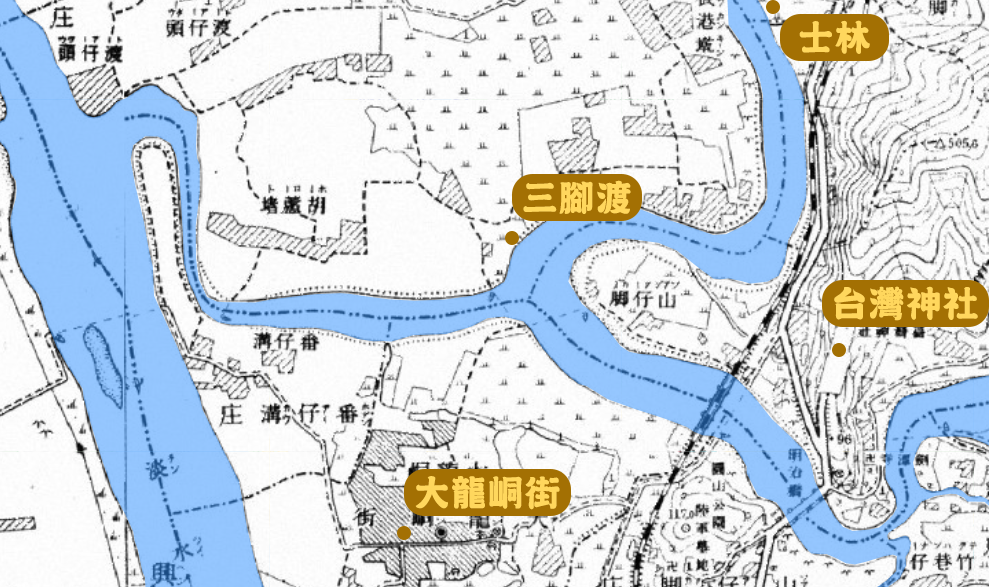
As you all thought, Shezi Island "originally" was indeed an island. From the map of the fort during the Japanese occupation period, it can be seen that the Keelung River is divided into two parts after passing through Zhongshan Bridge. On the road, it passes through Shuangxi, Chaumei and other places and finally connects with the Danshui River at Guandu; the other continues westward through today's Taipei Interchange, and connects with the Danshui River in the area of Fudui Pumping Station. The land separated by the two rivers and the Danshui River is what we now call Shezi Island.
The transformation of Shezi Island into a peninsula begins with a water conservancy project that changes the urban planning of Taipei City. After the lower Keelung River enters the flat Taipei Basin, the meandering flow is developed due to the different flow rates at the bends. In 1963, Typhoon Gellerley invaded Taiwan, and the torrential rain caused major flooding in the Taipei area. After the disaster, the government attributed the disaster to the strong meandering of the Keelung River and the narrowness of the Guandu River, which joins the Danshui River.

Therefore, in the follow-up, the relevant "Damshui River Treatment Plan" was promoted. First, the Gandoumen (Guandu) river channel was widened to 15 meters to divert the torrent, and then the river channel was rectified, and the Keelung River below the Yuanshan Zhongshan Bridge was intercepted and straightened. It is called the Keelung section of the Keelung River (or the west section of the Keelung River) to cut and straighten the project.

The plan began in 1965. The government will fill in the old river channels surrounding Jiantan and Shilin, and excavate a channel on the west side of Hougang Village on Shezi Island. A new river channel with a width of 120 meters, and a Bailing Bridge was built on the new channel to facilitate the traffic between the two places.
However, up to this time, Shezi Island was still an island and was not connected to any land. Until the early 1970s, when the Zhongshan Expressway was built, in order to fill the roadbed, the Fanzi that traverses Keelung and the Danshui River was further expanded. The ditch was filled with land, and the water of the Keelung River flowed into the Tamsui River from a straight channel, and Shezi Island was also connected to Taipei City and was no longer an independent island.

Another thing worth mentioning is that after the diversion of the river course, the land along the Jihe Road in the east is gradually becoming desolate. In 1979, the Taipei City Government proposed the "Keelung River Abandoned Channel Improvement and Utilization Plan Project" to fill up the original remaining river channel and use it as residential land. During the process, the Shilin Suspension Bridge built in 1939 was also demolished. This suspension bridge was originally an important communication channel for local people to travel between the two banks of the Keelung River, and it is of great significance to the people of Shilin. Therefore, when the Beijie Jiantan Station was built, the station was deliberately built into the shape of a suspension bridge as a commemoration.

Back to Shezi Island, there are still many relics in the Shezi and Shilin areas today to witness the existence of the old river. For example, at the northern end of the intersection of Section 3 of Huanhe North Road and National Highway No. 1, there is still a section of the original Panzigou waterway used as a waterway for the pumping station and drainage system; the intersection of Tonghe East Street and the second lane of Section 4 of Chengde Road is still there. The place name is "Sanjiaodu". This is the ferry crossing of Jiantan, Dalongdong and Shezidao in the past. It is called "Sanjiaodu" because it leads to the three places.

In addition to these relics, the seemingly glamorous Keelung River reconstruction project was not successful in hindsight. The widening project in the Guandu area actually caused the problem of seawater backflow in the Danshui River. Wugu Xiangzhouhou Village (now Wugu Wetland) Land) was the first to bear the brunt of the flood, and the fertile fertile fields turned into salinized rotten land as soon as the tide came. In addition, hundreds of hectares of river land between the originally curved meanders can be used as a floodplain for flood detention. Although cutting the curve straight creates a lot of new land, it also allows the water to rush to the downstream faster, which is harmful to the people in the downstream. Threats to life and property.

Since the opening of the Zhongheng Highway in 1960, Taiwan has always been filled with the atmosphere of "man can conquer the sky", and many constructions also believe that through the efforts of people, we can change the inconvenience caused by the world. But are the results really good? I think from the small Shezi Island to the peninsula and the renovation plan of the water conservancy in Taipei, I can carefully reflect on the meaning and right and wrong of these four words.
Like my work?
Don't forget to support or like, so I know you are with me..
Comment…