Nanyang Hall, Southern Imagination, Southern Taiwan
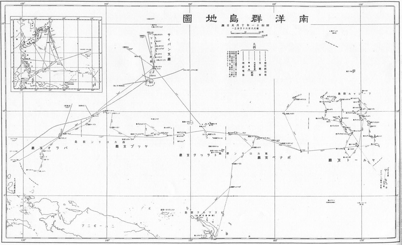
Usually we refer to the usage of the term "Nanyang", mainly referring to today's Southeast Asia (Southeast Asia), but in the administrative divisions of the old Japanese Empire, there is a "Nanyang Hall" and "Nanyang Islands/Nanyang" that are not in Southeast Asia. Islands”, that is, the islands located in today’s Western Pacific – the Free State of the Northern Mariana Islands, the Republic of Palau, the Republic of the Marshall Islands, and the Federated States of Micronesia. The "outer South Seas" are relative to the "Inner South Seas".
Today, most people will recognize from middle school history textbooks that Taiwan was the base of the old Japan's southward approach, and they also know that the purpose of the southward route is Southeast Asia - Nanyang. The Outer Nanyang and Inner Nanyang, which were only included in the bag, were set aside from the German Pacific colonies as early as the Versailles Conference. They were handed over to Japan by the League of Nations in 1922 under the mandate of Japan. That is, according to the League of Nations Agreement, the place "should be governed by the laws of the trustee country as part of the trustee state." Therefore, unlike the Middle East under the mandate of Britain and France, before the defeat of World War II, the Nanyang Office was basically regarded as Japan. fully ruled colonies.

In fact, in the southern imaginations of Qing/China and Japan, the definitions of Nanyang are also quite different. In Qing Dynasty, Nanyang refers to the waters south of the Yangtze River. After World War II, Taiwanese textbooks also inherited this view, so today Taiwanese are naturally unfamiliar with the scope of Nanyang defined by Japan. However, it can be found from here that basically the rulers of the two countries are self-centered and shape different southern imaginations in the name of Nanyang. To the Manchu and Mongolian military aristocracy, the ruling class of the Qing Dynasty, the south of the Yangtze River was the "south of the southern colonies." Coincidentally, this coincided with the scope of the cultural circle in Southeast Asia. In the "Greater Southeast Asia Hypothesis" proposed by the research model and many folklore research results, Taiwan, China south of the Yangtze River, Southeast Asia, the Indo-China Peninsula, and even the Assam region of the South Asian subcontinent are all included in the same ancient culture. (Note 1), this view was later accepted by the academic community:
"The 11th Pacific Science Conference held in Tokyo, Japan in 1966. The anthropology group defined the spatial category of "Southeast Asia" as 30 degrees north latitude (approximately equivalent to the mouth of the Yangtze River), reaching Sumatra in Indonesia in the south, the Irrawaddy River in the west, and the east Arrived in the East China Sea. Therefore, most of the research on the prehistory of South China, Taiwan and Southeast Asia, especially the research on the relationship between prehistoric culture, is considered from an overall cultural ecological location. "(Zang Zhenhua, 2003)
Japan’s concept of Nanyang is simpler. Basically, the sea area radiating from the mainland/mainland to the south is the scope of the Nanyang. It is only divided into two parts, the inner and outer parts, according to the sea area blocked by the Caihua Islands (the first island chain). In concept, the Nanyang Office and Japanese Nanyang refer to the "Inner Nanyang" part. These Pacific Islands were the legal territory of Japan at that time, not the Southeast Asian region familiar to Chinese users.
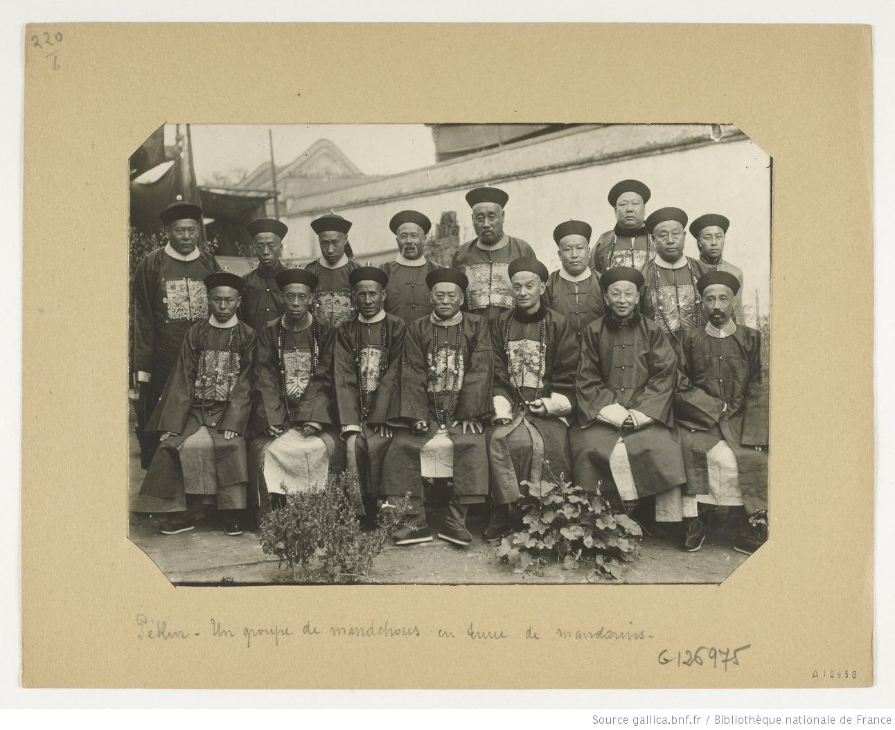
An interesting observation can be drawn from this, that is, both colonial empires, the Qing Dynasty did not become a modern neo-imperialist country like Japan, and the "colonial modernity" it imposed on the colonies was not obvious. In the photographic documents of the 19th and 20th centuries, the colonizers and the colonized in the Qing Dynasty were often packaged into "Orient" images (the Ottoman Empire, which had a similar colonial structure to the Qing, was also treated the same way. ). For example, we can see in this photo taken by Firmin Laribe (1855-1942), a French officer stationed in the Qing Dynasty (Note 2), in the group photo of a group of Qing officials, it is actually impossible to distinguish their ethnicity. In the eyes of Westerners, whether they are Manchus or Han Chinese, they belong to the "Oriental". Basically, the broad robes and opium rods are the visual impression of the Qing Dynasty to the West. Under the gaze of the West There is no obvious difference between the North Asian steppe culture and the southern colonies. They exist in the image together as objects of gaze.

However, relatively speaking, Japan's colonial rule is the closest to the West among Asian colonists, so its southern imagination can be presented through modern photography technology, and it does not need the endorsement of Westerners, such as through Lord Mullerney's In the diary, we learned that the "Tartarian princes" of the Qing Dynasty always took pleasure in making fun of the femininity of the colonized south. However, Japan’s southern imagination can be seen in many photos and videos. Take the development of photography in Japanese Taiwan as an example, because there is not much difference in skin color between Japanese and colonial people (after all, Japan’s ethnic composition is also partly Yayoi people from ancient Southeast Asia), so the early Japanese colonizers differentiated themselves from the colonized in terms of posture, clothing, shooting scenes, facial modification, etc. in the images. For example, during the Meiji Restoration, Japanese society competed to imitate the upper-class nobles in Europe The popular upturned mustache, or the slim suit that has been commonly worn in daily life. If we compare the "Mainlanders" (Naichi-jin) in suits and the "Islanders"/"Hontō-jin" (Hontō-jin) in Manchu-style robes and large sleeves, or the Japanese in European-style military uniforms and armed with modern weapons The comparison between the soldiers and the "Takasagun" in traditional costumes actually presents a picture: the difference between the colonizers and the colonized is equal to the distance between them and Western civilization.
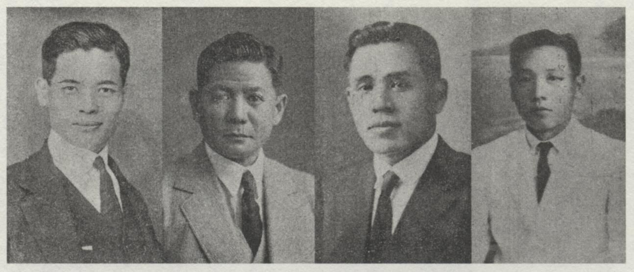
However, with the invention of the T-shaped razor in the early 20th century, and the rapid dailyization/westernization of the island's society in the mid-colonial period, the daily clothing of the island's gentry and elites has been dominated by suits. In the video, the colonists and most of the colonized are almost the same in appearance. For example, the American scholar Zhou Wenlong (Joseph R. Allen) wrote an article on portrait photography during the Japanese occupation "Picturing Gentlemen: Japanese Portrait Photography in Colonial Taiwan" In the list of people cited in the photo, the Japanese and the island's "gentlemen" are highly consistent in front of the camera - a face with a clean beard, a suit head carefully groomed with hair oil, a three-piece suit that fits so well. Readers have to look at the names to identify which of them is Japanese and which is Taiwanese.

Regarding the visual confusion between the equally modern Japanese colonizers and the colonized Taiwanese due to the small differences in racial characteristics, Zhou Wenlong believes that neither of them can and cannot be his imitation objects - Western white people This feature of , coupled with the postcolonial theorist Homi Bhabha's ongoing emphasis on the hybridity created by colonial mimicry, indirectly mocks the arbitrariness of colonial power.
Not only that, but this partially offsets Japan's efforts to construct the southern imagination through modern photographic technology, so the southern imagination of Japan in the post-colonial period instead focused on the climate and products, plant varieties, and governance achievements of the southern colonies. In the 1940 national policy documentary "Going to Taiwan" led by the Taiwan Governor's Office, the narrator said: "The first stage of our march to the south is to understand modern Taiwan, which is the source of our wealth... Taiwan is the southern part of the empire. The first level of the island.” Most of the focus of the film is to promote the modern development and tropical affluent life brought about by Japanese colonial rule, and does not introduce too much about the folk culture of the island’s society, only the last part specifically introduces “the mainland People are interested in the Takasago people," but it also emphasizes that they yearn for enlightenment, get rid of their "bad habits", "happy" to work hard, and cultivate the virtue of saving. In the picture, although they dance in traditional costumes, the narration also constantly emphasizes that this performance arrangement was actually resisted at the beginning, and they do not want to be considered to be dancing this kind of dance all the time, "They want to break away from the original life", and calling them "Fanren" would lead to a face-changing response: "We are also Japanese, please don't call us Tibetans", and the corresponding screen transition is to arrange for aboriginal women in Wu clothes And footage of Aboriginal men in patrol uniforms saluting.
At the end of the film, in the picture of the soldiers on the Eluanbi Lighthouse looking at the southern sea through the telescope, the narrator asks, "What's there?" Claiming that "there are dozens of times the uncultivated land of Japan" (in fact, almost all of them are colonies of the West), for Japan's survival, Taiwan must be used as a foothold to conquer the South, and finally in the narrator's call: "Go south! Towards the infinite treasury", we see the purpose of Japan's construction of the southern imagination with modern photographic technology - the strategic resources needed to carry out a total war.
However, this is only the interpretation of the first level, and the next level is still what I just said. In addition to the aborigines, the photographer seems to intentionally ignore and not "specialize" the people of the island. This may be during the imperialization movement at that time. , there is already a presupposition that the Taiwanese will be highly assimilated, and due to the similarities between the two discussed in the previous paragraphs, in the production of official images in the post-colonial period, it is rarely found in terms of characters that show Taiwan's exotic The elements of sentiment (except for the aborigines), on the contrary, demonstrate Japan's governance achievements (colonial modernity) by comparing the Chinese-style buildings before 1895 with the European-style streets and buildings designed by Japan's urban planning.
This also corresponds to the increasing trend of the number of Taiwanese opening photo studios in the late colonial period. At the same time, Taiwanese gentry elites have generally developed the habit of taking pictures. In terms of body image, their closeness to Western civilization is sometimes not It is inferior to the Japanese who are also imitators. Therefore, in the strategy of constructing the southern imagination, the Japanese colonists avoided the "defects" similar to those of the colonized people, and used modern photographic technology to publicize the colonial rule and the strategy of the south. legitimacy, and whether this “colonial relationship between the yellow race” is related to the rise of Pan-Asianism and Greater East Asia consciousness deserves further in-depth study.
Going back to the difference in the geographic scope of "Nanyang" in Chinese and Japanese, we can actually see the colonial structure of the two empires. conquered part of the cultural circle of Southeast Asia; for Japan, it was two colonial routes from the mainland south (Inner Nanyang, Outer Nanyang), only because Japan consciously used modern photography to discuss this intention and strengthen its structure, Therefore, in his geographical concept of "Nanyang", the nature of imperialism is more obvious, and the images produced based on this construction purpose - maps, photos, documentaries, etc., will not be classified as pure "Oriental images" ”, because the Japanese themselves are the gazers who master photography technology, they have the advantage of arranging the colonized people. Through the marking and naming of the “Nanyang Islands”, as well as the photography in the southern colony of Taiwan, Japan finally intends to build a system that can compete with the West. The colonial system of the Greater East Asia Co-Prosperity Sphere, but because there is no huge racial difference between the colonized countries like the Western colonial empires (such as Britain and India, France and Africa), therefore, in Japan, the East In the colonial structure of the only new imperialist state, there is an ambiguous weakening mechanism instead.
Note 1: "Not only in the peninsulas and islands in Southeast Asia. In the mainland, from the peninsula to the south of China, it reaches the Yangtze River in the north, and even beyond the river to the north as far as the south of the Qinling Mountains. It starts from the sea in the east and crosses the central and southern parts of China. West through Yunnan and Burma to Assam, India.", see Ling Chunsheng, "Research on Ancient Cultures in Southeast Asia", "New Journal of Ethnology Research Special Issue", No. 4, 1950. Also included in "Doctrine and National Policy", No. 44, 1955, 1-3.
Note 2: The album about Firmin Laribe can be inquired and read on the website of the digital library ( BNF Gallica ) under the French National Library and the French National Research Center East Asian Institute (CNRS IAO).
Like my work? Don't forget to support and clap, let me know that you are with me on the road of creation. Keep this enthusiasm together!


- Author
- More