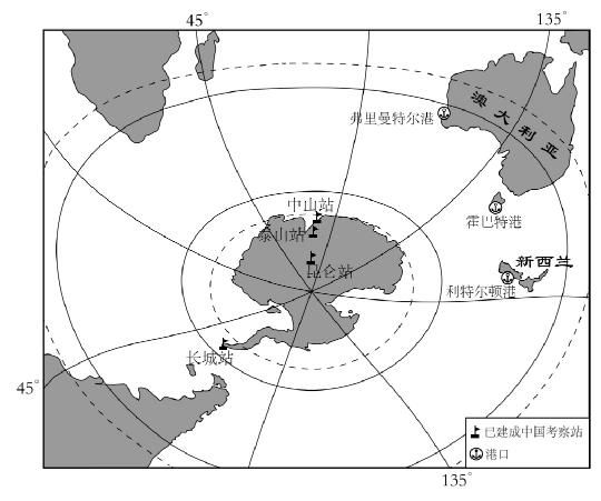
Antarctic expedition route selection

(1) my country chooses route a the most times, and the main consideration is that A. has the shortest voyage
B. Supplies along the way
C. smooth sailing
D. Avoid sea fog
(2) c route
A. Across the southern temperate zone and the southern frigid zone
B. crossed the date line
C. The national flag on the research ship often floats to the northeast
D. The research ship sails eastward
Answer
(1) A
(2) B
Parse
(1)
This question mainly examines the choice of Antarctic routes and the geographical features of the Southern Hemisphere. It can be seen from the figure that the longitude passing through Australia is 135"E, and the route a passes through Fremantle Port to Zhongshan Station, where the longitude is approximately 120E. The distance from my country to the Antarctic region is the shortest along the route a; The A option is correct, the BCD option is incorrect.
(2)
- A. The Great Wall Station is located outside the Antarctic Circle, and the c route (Littleton Port-Great Wall Station) is in the south temperate zone, so option A is wrong; Station) to reach the Antarctic area, it is necessary to cross Taiping, so the c route crosses the 180 meridian, so option B is correct;
- The Cc route (Littleton Harbor-Great Wall Station) is roughly along the westerly belt route in the southern hemisphere. The prevailing westerly wind in the southern hemisphere is the northwesterly wind, so the flag flutters to the southeast, so option C is wrong;
- D. Looking down over the South Pole, the direction of the earth's rotation is clockwise, and the Great Wall Station is located in the south of Littleton Harbor, so from Littleton Harbor to the Great Wall Station, the research ship sails southeast, so option D is wrong.
Like my work? Don't forget to support and clap, let me know that you are with me on the road of creation. Keep this enthusiasm together!
